- CCT Public Page
- [CCT Members Area]
Blog
search
attachments
weblink
advanced
Overview
Content Tools
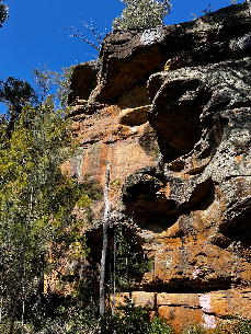
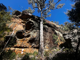
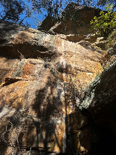
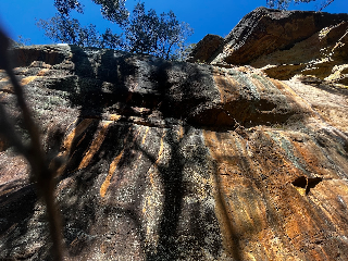
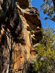
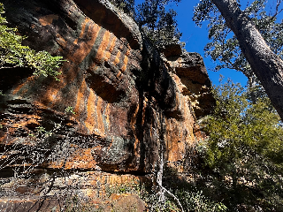
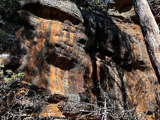
Was out looking for boulders today out the back of Sand River (didn't find much), but did spot this sick looking orange wall that I'm unlikely to develop so I thought I would record it's location for posterity.
If Forestry gave out the key to the gate (they don't - I've previously asked - they say they won't because you can get into the army range from this road), this would only be a ~300m walk from the road, but instead it's ~5km from the gate, with a decent bit of uphill at the start. Maybe 25 minutes on an e-bike. Or even better a motor bike.
There is more rock in this valley, but didn't spot anything anywhere near as good. Upstream there is grey rock near the creek (canyon) but it's a bit vegetated. You can see some more orange stuff at the mouth of the valley just to the south of Justin's place on the way out from Sand River, but it's (probably) on private land. But if anyone develops this it would be definitely worth exploring downstream to the boundary of the public land.
|
|
|
|
|
|

|
|
There were two men (and a dog) checking out the cars parked by the road at Sand River yesterday (22nd July) - they drove off in a van when waved to as we approached. Maybe all very innocent but... Take valuables with you I guess.
I've been enjoying the Lowdina renaisassance lately, working through a full spectrum of easy and moderate routes. I'm curios about Expiry (13) on Lumbar cruncher buttress. In the topo photo which can't be very old at all there is a large chockstone visible in the offwidth. This was missing when we climbed the route the result being its seems pretty arduous for the grade.
Did somebody make the world a safer place or did it fall out by its own volition?
Found a polarfleece at the top of the sandstone cliffs in Waterworks Reserve Mon 11th July.
If it's yours let me know colour and brand and how to get it back to you.
Cheers, Tim
Hi everyone,
Crag Care is running a working bee at Fruehauf on the 17th of July from 9-12 noon with the Hobart City Council Bushcare team. The council has asked that we close the cliff during that time! But it'll be back open straight after the working bee has finished.
Come along! It should be a nice morning of planting, weeding, chatting and cake. More details here: https://www.cragcaretasmania.org.au/event-details/fruehauf-working-bee
A recent severe wind related weather event has resulted in multiple trees falling across the track which accesses Mt Roland cliffs. Of concern, is that there are many "widow maker" branches hanging, waiting for an unsuspecting person to walk underneath. There is a very high risk of one of these branches falling without notice. It is recommended to avoid the area for a couple of months to allow the forces of gravity and changing winds to do their work in bringing some of these branches down to earth. Some track clearing with a chainsaw has commenced - more will be done when time permits.
I've not been to the Knuckle before, so anyone with some experience there would be greatly appreciated. I am wondering if it might be in condition by Monday 13th.
I've been looking at the Stacks Bluff forecast; not sure if there is a more suitable one. Looks like all the precipitation leading up to Monday is probably snow, rather than rain, which on a South facing slope that is mostly water ice, I wonder if this will not work well. There are strong southerly winds all week, however they seem to improve somewhat by Monday.
https://www.mountain-forecast.com/peaks/Stacks-Bluff/forecasts/1527
https://www.willyweather.com.au/tas/northern/stacks-bluff.html (Willy weather less optimistic about how cold it is going to be)
Forgot my shoes at Blackwood Rocks last Saturday 19 March at Blackwood Rocks at McGifford's Edge (right under Aperitif) if anyone has found them please please let me know.
Shoes found!
Hi all
I found a watch at lassies wall on Sunday. If it is yours let us know and
I can post it to you or I can drop it off at the gym.
thanks Garry
TheSarvo appears to be lacking in a guide for (Northern) Badgers beyond a mere mention in Other Northern Crags. TheCrag has a list of climbs in the area but a bit short on detailed beta for which crag is which.
I don't have access to my copy of Climb Northern Tas so I don't know what's in there or how up-to-date that is.
Anyone on here with the goss for the area and happy for me to pick their brains?? GPS coords of which wall is where from TheCrag.com mostly.
Cheers
Dave
Hi all, it's with great sadness that I have to say I seem to have lost a rope on the pipes. Annoyingly it's hard for me to pin down where and when. Likely in the last 3 weeks and around heat is most likely or perhaps the pinnacle Road car park.
Keen to know if one has been found. Black singing rock rope bag - simple back pack style and a 60m bicolour TC pro rope, green.
Hopefully a resolution to the mystery is to be found.
Safe climbing!
Crag Care is running an erosion control working bee at Flange Buttress on the Organ Pipes this Sunday 20th of Feb. As a result, Hobart City Council (who are supervising the working bee) has requested that Flange Buttress, from Fiddlesticks to The Tower of Power (including Neon God, After Midnight and Pleasant Screams and all the climbs between) be closed to climbing from 10am-3pm. This will keep climbers and ropes out of the worksite.
Sorry for any inconvenience caused, the works will help manage erosion cause by ropes and foot traffic at the site, so benefiting the universe in the long term.
Have fun out there!
The sign re- Peregrine falcons at the left hand end of the Panopticon has been taken down and is stored under Bentham Wall, ready for next year.
BTW, last two weekends at the Panopticon we have had big brown ticks on us, maybe due to the wetter than average spring/summer rains - worth checking after a session up there.
Hi Everyone
Just letting people know that there is a birds nest 1m right of the climb Princess.
The nest is at the 2nd bolt. I think it would be good to have a climbing ban on this route and Nefarious until they have gone away.
If some one wants to post this on the crag as well as Facebook that would be great.
We should probably also put a tag on the 1st bolt as well.
CLIMB TASMANIA GUIDEBOOK REVIEW by Simon Mentz.
Here is what one of the authors of the Mt Arapiles guidebook, Simon Mentz, thinks of the new Tassie guidebook. Please share this to as many of your friends as you can. Thankyou
CLIMB TASMANIA (3rd Edition) by Gerry Narkowicz
Review by Simon Mentz
For an old jaded climber like me, seeing the latest edition of Climb Tasmania was the shot in the arm that I needed. This isn't just a reprint of the former excellent guide with a few extra titbits thrown in, but a complete re-working of the book... new layout, new topos, new maps, new photos, new crags.
Unfortunately, Hillwood has gone due to access problems, but at least low to mid-end climbers can enjoy the inclusion of Sand River, a friendly sport climbing area not too far from Hobart. Among the other more significant areas to debut in this edition is Cloudy Bay down on Bruny Island which hosts a bunch of moderate sport routes in a seaside setting. I was glad to see the inclusion of Fruehauf, which despite being a chipped quarry is still a worthwhile place to spend a few hours when the weather is crap on 'the Pipes' above Hobart. Boulderers haven't been forgotten either with 14 pages dedicated to various pockets of bouldering scattered around the state (but you will need to do a bit more research if bouldering is all that you do).
The new layout and graphics are pleasing to the eye and also make this guide both user-friendly and appealing to read. And there is plenty to read! Gerry's love of the history of Tassie climbing shines through with not only a History Timeline at the start of the book, but a history chapter for each area and finally 'Star Wars'... a piss-take of the characters, the development, the ethics and the fueds that have dominated the Tassie climbing scene over the last few decades.
Visually the guide is well served by a variety of photographers, but in particular the work of Simon Bischoff lifts the book to world-class level with his cliff photos and action shots. The designer Boris Petrack has matched the cliff photos with topo graphics to convey all the necessary information in a clean and attractive way. Print quality is superb and many enjoyable hours can be spent pouring over the cliff photos and excellent maps to familiarise yourself with each area.
There is an abundance of updated and re-worked information in this book, much of which is far more detailed than what appeared in earlier editions. Gerry has called on a host of people to write and update different regions and this will be particularly appreciated by climbers launching onto those cliffs where route descriptions and topos were seriously lacking. Climbs such as the Candlestick and the Geryon Traverse now have far more detail for those wishing to tackle them. These climbs however remain very serious adventures (despite their relatively low grades) and shouldn't be underestimated.
I suspect there are a bunch of other more-subtle elements to this book which I have failed to mention, but which I will come to appreciate over time. One element that did jump out was the inclusion of yellow boxes which tell a bit more story behind iconic Tasmanian climbs, which was a nice way of injecting a bit of character into those pages dominated by dry route descriptions.
While I might question the allocation of stars occasionally, particularly by a handful of first ascentionists getting carried away with their latest creations, such gripes are not really worth mentioning in a book of this magnitude. There is little doubt that Gerry has done Tassie climbing proud, along with everyone else who has contributed to it.
Fortunately, the book is out just in time for the upcoming Tassie climbing season, so treat yourself and/or a friend by buying a copy and start planning your next climbing holiday to the magic island state.
You can order Climb Tasmania online from climbtasmania.com.au $64.95 plus $10 postage.